アイスランド②/Iceland ②
地球がのたうち、呼吸する場
アイスランドに着いて2日目です。本日は車を駆ってギャウと間欠泉を観に行く予定。ギャウとは一言でいうと“地球の裂け目”。アイスランドはユーラシア・プレートと北アメリカ・プレートの境目となる大西洋中央海嶺の真上に位置しています。大西洋のほぼ真ん中を北極海から南大西洋まで連なる中央海嶺は地球深部からのマントル対流によって両側に常に盛り上がりを続けており、現在でも年間で数cm程度、両方の大陸に向かって広がりを見せています。中央海嶺の大部分は海底に存在しているわけですが、アイスランドは世界で唯一この海嶺が陸上に現われた場所であり、新しい大地が形成される場面を見られる世界でただ一つの場所。アイスランドに来た大きな目的は、こうした「世界でここでしか見られないもの」を見るためなので、今日はまさにその第一ステップ。残念ながら天気は引き続き雨が降ったり、やんだり。この季節にはつきものの天候のようです。
Earth is floundering and breathing
This is my 2nd day in Iceland. Today’s plan is to go to see Gyau and Geyser by car. Gyau is the “Crevices of the earth”. Iceland is positioned on the Mid-Atlantic Ridge which is the border between the North American plate and Eurasian plate. The Ridge runs from the Arctic ocean to south Atlantic Ocean and the mantle convection from deep in the earth is spreading it in both directions a couple of cm every year. The Ridge is mostly seen at the bottom of the ocean but Iceland is the only place where you can observe this Ridge and the growth of new born earth on the ground. My main purpose in Iceland was to see this kind of “only one place in the world” and today is the first stage of the trip. However it is still raining. This weather can be quite common in this season.
(English text continues to the latter half of the page)
こうしたギャウと間欠泉群はゴールデンサークルと呼ばれるレイキャビクから60Kmほどのところに散在しています。まず向かったのはエリアで一番遠いところにあるヒャルパルフォス(Hjalparfoss)の滝。
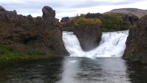
別々の水源から流れてきた川がこの滝を以て合流するところです。割と小さく地味な場所ではあるけど、とにかく水が透き通って美しい。
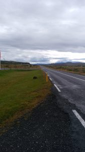
それにしても驚かされたのは、道路の法定速度。ほとんどの行程は上の写真にあるように、溶岩台地のうえを走る路肩もない片側一車線の道ですが、この道路の法定速度が90Km、たいていの車は100Km以上の速度で走っています。自分もあまり行儀のよいドライバーではないのですが、さすがに90Kmの法定速度には無理があるのではないか、と感じました。もっともこれは法律の精神、というかロジックの違いかもしれません。日本の場合、法定速度はあくまで“上から与えられるもの”で、現実には法定速度が50Kmでもドライバーは自分が実質的に安全だろうと感じる65Kmくらいで走っていることが多い。この国の法定速度はむしろドライバーが実際に走るであろう速度を最初から上限の速度にしているのかもしれない。ただこれは想像に過ぎないので、実情を知っている方がいればぜひ教えていただきたく思います。
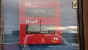
ちなみにこれがガソリン価格、上の199.9クローナというのがレギュラーガソリンのリッター当り価格。200円以上ですから日本と比べても5割高、他の欧州各国と比べても軒並み倍以上ではないでしょうか。アイスランドの物価高はここにも表れています。
次に訪れたのがグトルフォス(Gullfoss)の滝、朝日を受けて輝く黄金の滝の意味らしいですが、何よりも驚いたのはその轟音。ちょっとスケールの違う連なる滝は見応えがあります。
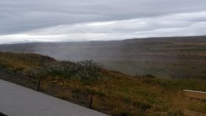
丘の上から近づいた時点ですでに霧が舞い上がっているのがわかるでしょうか。そしてその先に見えたのが下の写真。
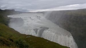
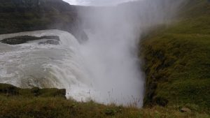
小生の下手な写真では圧倒的にダイナミックな様が伝わらないのが残念!ちなみに水しぶきの下にあった構造が以下の写真。
しかしそれにしてもこの場所でもアジア系のツアーグループがやたらに目立ちます。
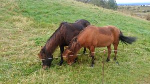
道すがら道路脇で草を食んでいた牧場の馬。アイスランドのローカル馬はけっこうずんぐりしてます。
次に向かうのが、間欠泉群があるゲイシール(Geysir)。ミネラルウォーターのクリスタルガイザーでお馴染みですが、間欠泉を英語でGeyserと言います。この単語はまさにこのゲイシールを語源としています。
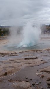
こんな感じの間欠泉がエリア一帯に散らばっています。
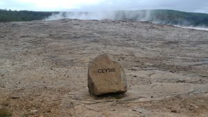
これがかつての間欠泉の代名詞だったGeysirそのもの。近年になって地中の構造が変化したのか噴き上がりがなくなり、その手前のストロックル(Strokkur)が5⁻10分に一度派手に噴き上がっています。下にあるのがその動画。20秒ほどお待ちください。
大きく噴き上がる前の水面は一定のリズムで上下し、まるで地球の呼吸を間近に見ているよう。
遂に本日の最終目的地ギャウのあるシンクヴェトリル(Thingvellir)国立公園に到着。
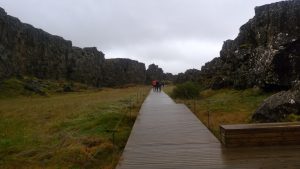
左側に盛り上がっているのが北アメリカ・プレート、右側がユーラシア・プレート、その間の土地がまさに生まれたばかりの大地で、中央に遊歩道が通されています。
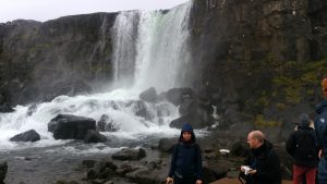
北アメリカ側からは川が流れ込んで滝になっています。
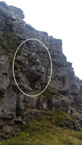
北アメリカ・プレート側の崖の一部に面白い
岩の形状を見つけました。「猿岩」といったところでしょうか。
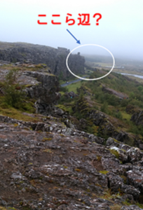
この「猿岩」のあたりで北アメリカ側の崖が高くなります。「欧州最古の民主議会」と呼ばれるアルシングが開かれていたのがこの辺りになります。自分も大学受験の時に世界史でその名前を聞いたことを思い出しました。アイスランドへの植民が本格化したのは900年頃の話、当時の植民者は主にノルウェーのほか、スコットランド、アイルランドのケルト人などでしたが、彼らは約束の地で出身地ごとに武力で勢力争いをしたり、王制を抱くのではなく、定住地ごとに代表者を選出して、毎年6月にシングヴェトリルの「法律の岩(Logberg)」の前に2週間集まり、政治的な議会から裁判、交易、見世物などの娯楽まで行いました。それがアルシングです。そもそも「シングヴェトリル」という言葉自体が、アイスランド語で「議会の原野」を指す言葉だそうです。6月は欧州で最も気候の爽やかな時節、恐らく毎年ここに集った各地のコロニーの人々にとっても、アルシングは単なる司法と話し合いの場に留まらず、大きなお祭りと“出会いの場”にもなっていたでしょう。時は930年、日本で言えば平安時代、欧州でいえば神聖ローマ帝国が成立、中国では後唐の時代、北アメリカではもちろんまだ歴史的な記述は残されていない時代です。アルシングは近世の植民地化によって一時中断するものの現在でも基本的な議会の形として存続しています。1944年にアイスランドの独立宣言が行われたのもこの地においてでした。なぜこの地がアルシングの開催地に選ばれたのかは定かでないのですが、切り立った岩が天然の劇場効果を発揮して声が通ったのに加えて、周辺に天幕や一時的な施設を展開できる広大な土地が広がっていたからかもしれません。何よりも国土を貫く大地の裂け目ギャウに沿って歩いていけば自然と行きつけるという場所だったことも大きいでしょう。アイスランド人が誇りとする欧州最古の民主議会の場は、20世紀後半のプレートテクトニクス理論の発見によって、現在では世界中から観光客を呼び寄せる何物にも代えがたい価値を生む場所になりました。
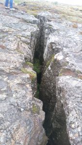
これも小さなギャウ?北アメリカからユーラシア大陸まで一跨ぎすることができそう。
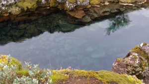
ギャウの底から湧き出す水は、北の氷河から30年かけて溶岩に磨かれたもので、恐ろしいほど青く、凄まじいほどの透明度。毎年開かれたアルシングに集まった人々の喉を潤し続けたのもこの水でしょう。
Earth is floundering and breathing
This is my 2nd day in Iceland. Today’s plan is to go to see Gyau and Geyser by car. Gyau is the “Crevices of the earth”. Iceland is positioned on the Mid-Atlantic Ridge which is the border between the North American plate and Eurasian plate. The Ridge runs from the Arctic ocean to south Atlantic Ocean and the mantle convection from deep in the earth is spreading it in both directions a couple of cm every year. The Ridge is mostly seen at the bottom of the ocean but Iceland is the only place where you can observe this Ridge and the growth of new born earth on the ground. My main purpose in Iceland was to see this kind of “only one place in the world” and today is the first stage of the trip. However it is still raining. This weather can be quite common in this season.
Those Gyau and Geysers are interspersed in the area called the Golden Circle which is 60-110Km away from Reykjavik. The first destination is Hjalparfoss waterfall which is the furthest away in the area.

Two different sources of water confluence at the waterfall. The place is relatively minor but the water is so clean and beautiful.

What is surprising is the speed limit on the roads. Most of the country roads are one lane roads without road shoulder on lava plateaus and the speed limit is mostly 90Km and most of vehicles are driving at 100Km. Even though I am not a very well-behaved driver, 90Km seems quite wild. But I also thought that the spirit of the law might be different. In Japan speed limit is something “given from the above” without actual considerations. When the government fix speed limit of a street at 50Km, drivers drive often at 65Km which they take as safe there. The speed limit in this country could be decided according to the speed which most of drivers would drive. However this is only my imagination, I’m happy to have opinions if somebody knows the truth.

And this is local gas prices. 199.9IK above is the regular. It is over \200/L, 50% more expensive than Japan and could be more than double compared with other European countries. This is just one proof of rising prices of Iceland.
Next destination is Gullfoss waterfall (read like Gutllefos). The name means Golden fall reflecting sun rise. My first surprise was its roar. Spectacular continuous waterfalls are really picturesque.
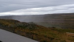
Over the hill is falls. You can already observe huge splashes from here.

It is quite a shame that my poor photos cannot express its dynamic scene!
Under splashes is the photo below.

Incidentally Asian tour groups stand out even here.

These are friendly horses eating grass together on the street. Icelandic horses look stocky.
Next destination is Geysir, special area of Geysers. The English word of “Geyser” off course came from this Icelandic word.

You can see a bunch of Geysers here and there in the area.

This is the original Geysir. It had shown magnificent splashes periodically before. Nowadays it became quiet maybe because the underground structure has changed. An another Geyser named Strokkur is now showing beautiful splashes every 5-10 minutes like the video below. Please be patient for first 20 seconds.
You can see the water surface comes up and down in a certain rhythm before splash. It truly looks like the breath of the earth.
Finally I have reached Thingvellir National Park, the final destination of the day.

The left cliff is the North American plate, the right is the Eurasian plate. You can walk on the pavement on “new born earth”.

A river is flowing from North American side.

Interesting figure of the rock on North American side. It could be called “Monkey Rock”.
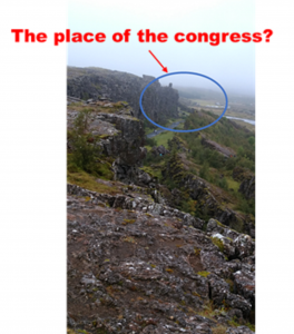
Around this “Monkey Rock” the North American cliff becomes tall. It is the place of Althing, the oldest democratic congress in Europe. I slightly remember I learned this before University entry exam. It was around AD900 when colonization into Iceland took its peak. People immigrated mainly from Norway, and Celts from Scotland, and Ireland. First generation of immigrants did not go into violent battles or monarchical system in “Promised land” but headed for a democratic parliamentary system. Delegates from each colony gather at “The rock of the law(Logberg)” in Thingvellir on June for 2 weeks and discussed problematic issues, made judgements, and also they traded things or enjoyed entertainment programs. This is Althing. The word “Thingvellir” means “Wilderness of the Congress”. June is the most comfortable season in Europe. For people gathered in Althing it was not only the place of discussions and judgement, but also that of festival and tying people together. First Althing took place on AD930. It was Heian era in Japan, the beginning of Holy Roman Empire in Europe, late Tang dynasty in China, and in North America there was no historical descriptor yet. Althing took place every year at the same place. Even after the Interruption due to colonization by other Nordic countries in early modern period, it exists as basic modern congress system nowadays. The declaration of Independence was pronounced at this place in 1944. It is not sure why Thingvellir was chosen as the place of Althing. However you can guess the rock behind might have worked as natural theater effect and there were enough hinterland for tents and temporary facilities. Moreover Gyau traverses the whole Iceland, if you come along the Gyau, people can easily get there.
Amid the discovery of the Plate tectonics theory, the place of “the oldest European democratic congress” which Icelanders are proud of has become unchangeable natural asset which invites millions of tourists from all over the world.

Is this also small Gyau? You can step across between Europe and America.

Fresh water fountaining from the bottom of Gyau is originated from northern glacier and is filtered by lava rocks for 30 years. It is awfully clean and transparent. This has moistened throats of people gathered at Althing.
